Optimizing Urban Accessibility: Building a 15-Minute City with Steiner Tree Approximation
 Join Trial or Access Free ResourcesJoin Trial or Access Free Resources
A Research Paper by Prishaa Shrimali (USA, Grade 10)
Urban planning is increasingly focused on creating sustainable, accessible cities where essential services are within easy reach. The 15-minute city (15-MC) model is an innovative approach aimed at structuring urban spaces so that residents can access key services, like healthcare, shopping, and recreational facilities, within a short walking or biking distance. In the study Optimizing Urban Accessibility: Constructing a 15-Minute City Using Steiner Tree Approximation, researchers introduce a method of applying graph theory—particularly the Steiner tree problem—to efficiently design 15-minute cities.
The study employs the Steiner tree problem, which seeks to find the minimum-weight network that connects selected key points, called terminals (e.g., service locations). Using this graph-based approach, the model minimizes travel time between key amenities by optimizing the pathways that connect them. Unlike models that place a focus on residential areas, this approach prioritizes service locations, making it computationally efficient.
The model is applied to Manhattan, using the city's pedestrian network to highlight service accessibility. Here, amenities such as pharmacies, post offices, and supermarkets serve as the Steiner tree's focal points. The OSMnx Python library is used to pull data from Open Street Maps, allowing for a practical analysis of service accessibility within a 15-minute walking radius.
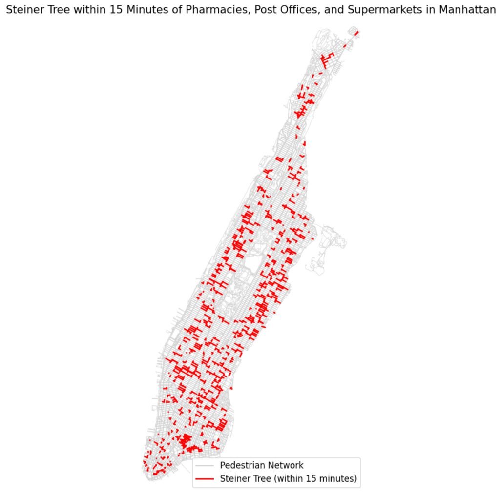
The Steiner tree-based method for designing a 15-minute city provides urban planners with an actionable framework to improve urban accessibility. While central areas of Manhattan demonstrate a high density of accessible services, regions like northern Manhattan could benefit from increased service points or better connectivity. This graph-based approach also shows promise for future expansions, such as multi-criteria optimization considering factors like environmental impact and cost.
In sum, the paper underscores the effectiveness of leveraging graph theory in urban planning and establishes a solid foundation for implementing sustainable, accessible city models that can adapt to the unique needs of various urban landscapes.

Publishing original scientific research in a peer-reviewed journal is an achievement many scholars work toward for years. Achieving this feat early in one's academic journey requires exceptional intellectual rigor, creativity, and persistence. Aaditya Punatar and Muskan Sadana have reached this remarkable milestone, successfully publishing their collaborative research paper in the prestigious Journal of Emerging Investigators […]
Her project on quantum-accelerated Steiner trees for 15-minute cities earned a place among the finalists at the world's largest pre-college STEM competition. Prishaa Shrimali of Marymount School of New York, was selected as a Grand Finalist at the 2026 Regeneron International Science and Engineering Fair (ISEF) in Phoenix, Arizona. Her project was Optimizing Urban Accessibility: […]

In 2026, the following Cheenta students have been successful for Indian Statistical Institute's M.Stat Entrance. They ranked within the first 50 in the entire country in these entrances. I.S.I. M.Stat Entrance
In 2026, the following Cheenta students have been successful for Indian Statistical Institute's B.Stat Entrance and Chennai Mathematical Institute's B.Sc. Math Entrance. They ranked within the first 200 in the entire country in these entrances. Most of these students attended the problem solving workshops regularly, which happen 5 days every week. CMI B.Sc. Math Entrance […]